MSIT - Ministry of Supply and Internal Trade - Egypt
Geo-Spatial Platform
Business Needs
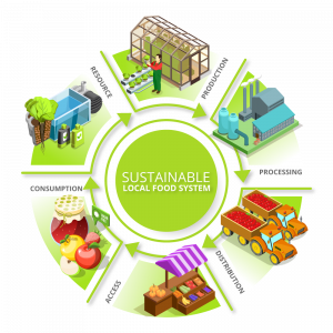
Ministry of Supply and Internal Trade Geo-Spatial Platform (Egyptian MSGP), was designed to support the Egyptian Government achieve its sustainable development goals, with a focus on food security theme, fair nutritional resources distribution, and well-managed grain silos.
The geo-empowerment needs emerged from MSIT's desire to
- Support their decision-making process by acquiring tools to help them link supply with demand across Egypt,
- Identify locations that may be considered “Food Deserts ” and ensure that residents in these areas have access to food suppliers in support of the Egyptian Sustainable development objectives.
- Tighten MSIT’s supervision on food supplier and identify violation hot spots
- Reach out the public and enhance their accessibility to services supported by MSIT
Solution Concept
Established in 2019, as a focused platform intended to support the establishment of a food security portal for the country.
The Ministry of Supply & Internal Trade Geo-Spatial Platform, has four main components

Golden Points
The Ministry of Supply and Internal Trade Geo-Spatial Platform (Egyptian MSGP) has many aspects of success and excellence, as well as lessons learned to disseminate and replicate to benefit other countries, in particular:
- Platform sustainability: The platform was built with a special focus on capacity building, knowledge transfer to MSIT Staff to ensure they are empowered to continue operating and updating the platform with the necessary content.
- Unification of resources: The platform provided a centralized geo-enabled repository, which hosts the different datasets pertaining to food security and nutrition, thus empowering a one-stop shop portal, which hosts supply and demand data, with an easy to use and intuitive web GIS functionality for searching, discovering and analysis.
- Enhanced decision support: Having a unified platform for food security helps decision makers access accurate data in a timely manner, thus supporting the decision-making process and enabling fast response. Moreover, maintaining the content within the platform helps with the creation of historical data, which will eventually support trends analysis and prediction.