De-risk Agriculture Development Projects
Support the Production of More Food in a Sustainable Way Through Better Planning
Current Status
Empower governmental institutes to perform analytical workflows to support determination of what yield can be expected from the water available for the crops. How efficiently water is used. The precise amounts of nutrients or seeds to apply through analysis of soil and yield data.
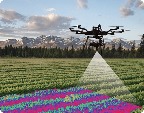
One of the huge benefits of the utilization of geospatial solutions will be bringing the results of advanced remote sensing analysis to the farmer’s hands.
In precision agriculture, the grower needs detailed information about the field. Key information is gathered from soil testing and yield data to determine the precise amounts of nutrients or seeds to apply. Using precise amounts increases yield and reduces waste, thereby increasing return on investment.
The use of Artificial Intelligence in agriculture is one of the most important applications that must be highlighted. As Agriculture Automation is the main concern and emerging subject for every country to provide and reserve their annual storage of food and to optimize problems that face agriculture sector like manage crop disease infestations, pesticide control, weed managements, irrigation, and water management to minimize water wastage.
The Advantages of Our Solutions
EFFECTIVE SOLUTIONS FOR BETTER RESULTS
Crop Mapping and Field Boundary Detection for the Agricultural Research Center (ARC), Egypt
QSIT implemented an artificial intelligence (AI) and remote-sensing spatial analysis solution to establish a dynamic, seasonal digital inventory of crop patterns.