Security & Intelligence
Governments Seek the Implementation of an Integrated Solution, to Support Law Enforcement and National Security
Security & Intelligence
Today, our nation is exposed to threats, either natural or fabricated, which require full-scale situation assessment, mitigation, preparation, and response. This new reality entails rethinking policies, plans, and allocation of resources. Hence, it has become inevitable for any concerned authority to work on ensuring the safety and security of its citizens and borders, securing and protecting national assets and properties, as well as maintaining the social safety.
In light of the above, the Intelligence Information Systems Departments seek the implementation of an integrated solution, to provide the strategic leadership with unified common situational awareness through geospatial information intelligent technologies.

Key Challenges

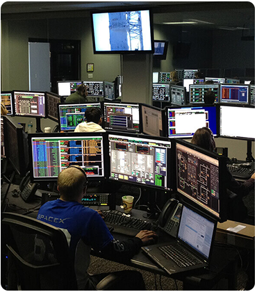
Real-Time Operational Support

Full Situational Awareness

In-field Collaboration

Understand a Complex Situation

Shorter Time and Accurate Response
Our Solutions and Services
In response, QSIT is offering multiple products and solutions that address nation needs on the three main levels operational, tactical and strategic.
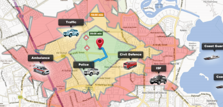
COP – Common Operational Picture Solution
Common Operational Picture Solution that supports planning of mission and operation in addition to situation awareness. The solution enables the manipulation of geospatial data to allow for displaying and managing mission scenarios elements such as basemaps, operational layers, reports, and current situation overview, on three main levels:

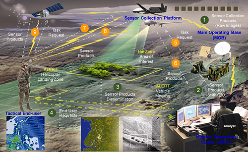
GeoInt - Geospatial Intelligence Solutions
Geospatial Intelligence Solutions that supports reportedly coordinates, integrates, and synchronizes geospatial information and standards across the forces, develops and fields geospatial enterprise-enabled systems and capabilities to the forces and provides direct geospatial support and products to Warfighters. With tools that helps Geospatial Research and Engineering Division in Development Center asset, conducts research and development into geospatial data collection, processing, exploitation, and dissemination in support of both civilian missions and missions of ground forces. With solutions such as:
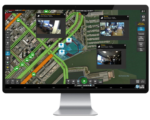
Geographic Security System GSS™ for Response Agencies
Geographic Security System GSS™ for Response Agencies – is a comprehensive, on-premise web-hosted, Geo-enabled incident information management system designated for spatialized forces safety command and control Centers; facilities with CFSs, capability for receiving calls assigned to telephone number for emergency/non-emergency services via standard integration interface with CTI solution, operated on a 24-hour basis, and, as appropriate, dispatching emergency services.
Web GIS Platform for Intelligence
Web GIS Platform for Intelligence – Solution that provides content management as well as content sharing and collaboration capabilities to its users.
This system, the Web GIS Platform, will connect users at its headquarters with bases. A Portal for component will facilitate the sharing and access of geospatial assets and applications, while supporting the management and publication of the content. The QSIT anticipates using the GIS platform and its Web GIS capabilities for implementing the intelligence Web GIS Platform and underlying capabilities.